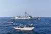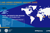


February 9 - A new interactive map - RiskMap - has been launched so that shipowners and managers can easily view what security threats a country poses to shipping lines.
RiskMap explained that it automatically analyses thousands of news articles every day, by assessing the threat posed, classifying the risk and identifying the location. It then automatically summarises articles of interest by selecting the most important information that is relevant to the event. The risks identified represent issues surrounding security, health and migration and can include anything from earthquakes to conflict updates.
"This is a real game changer, not only for ship owners and managers, but anyone who deals with the movement of equipment or humans," said James Morgan, IT developer at RiskMap Intelligence. "It provides them with one source for getting an instant picture of what's going on in a particular place. It's a platform that gives you the intelligence you need to build risk assessments."
The website includes a world map with dots displayed on each country that users can click to find out the risks or threats they represent. Users can also access information on the ports and view the services available at those locations. Countries are allocated a colour on the map that represents how high or low risk it is, with the highest risk countries being displayed in red.
RiskMap Intelligence, part of The Marshals Group (TMG), has been under development over the last two years.
Morgan added: "A lot of our clients were demanding risk assessments linked to piracy on both the east and west coasts of Africa. We started collecting information and developed an internal system where we stored everything. But we soon realised its potential, so we decided to set it up as its own brand, under its own company and launch it to the public."
www.riskmap.com